Original: $15.95
-65%$15.95
$5.58The Story
A fully updated and richly detailed road map of Scotland – your essential guide to the Highlands, islands, and everything in between
Whether you’re embarking on a once-in-a-lifetime journey along the North Coast 500, tracing your ancestry through the Borders, discovering the mythic beauty of Loch Ness, or navigating the vibrant streets of Edinburgh and Glasgow, the Collins Scotland Folded Map 2027 Edition is your trusted travel companion.
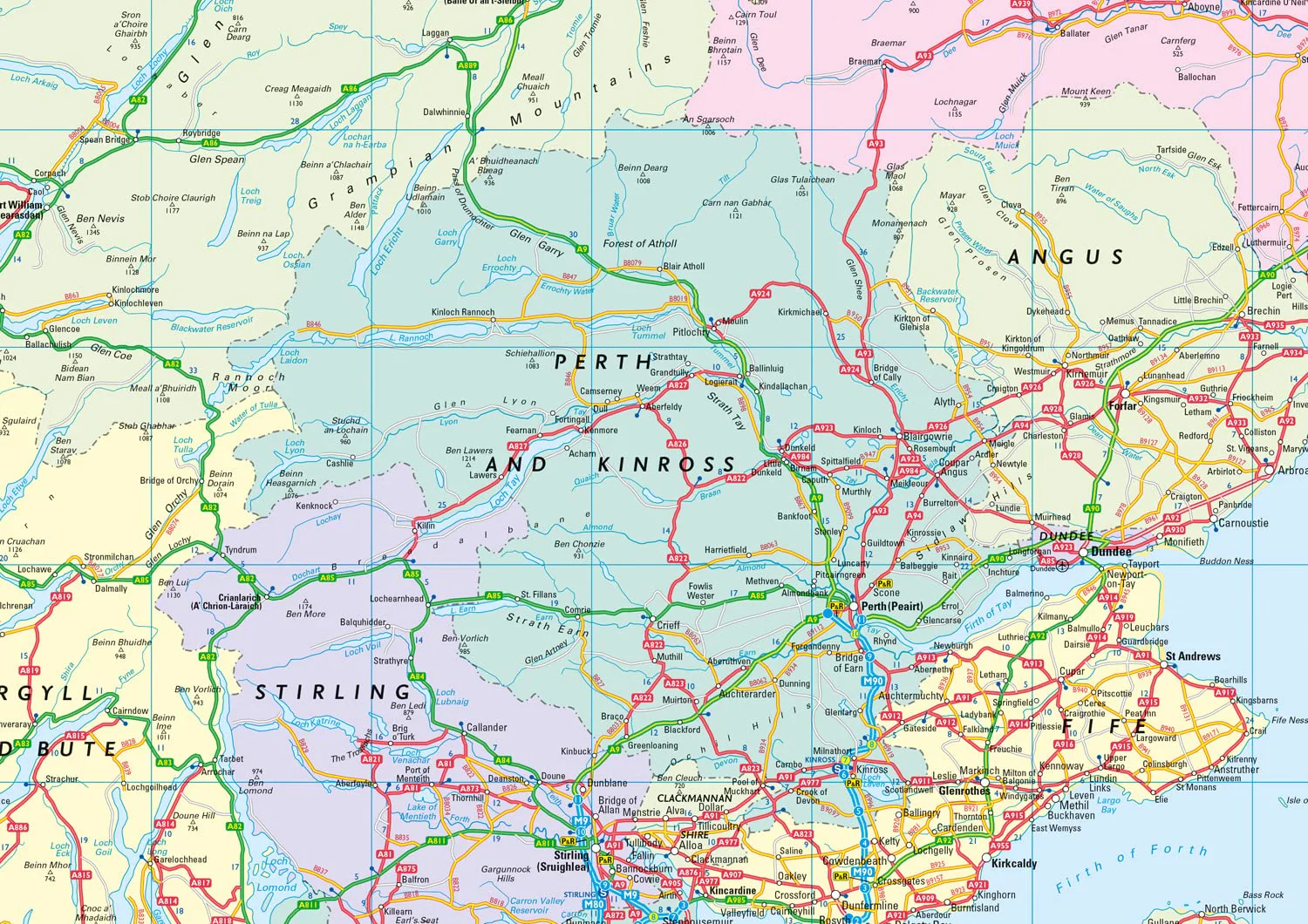
With its clear cartography, logical layout, and full national coverage, this map is perfect for road trippers, tourers, cyclists, holidaymakers, and professional drivers alike. It includes everything you need to plan your trip, find the best routes, and discover scenic detours—all in one compact, easy-to-use format.
🗺️ Key Map Features:
-
Full road coverage of Scotland, from the southern borders to the wild northern coast, including the Inner and Outer Hebrides, Orkney, and Shetland Islands
-
Motorways, A-roads, B-roads, and local routes clearly colour-coded for easy reference
-
Scenic routes, tourist drives, and key viewing points marked throughout for leisure travellers
-
Includes ferry routes, ports, and terminals—essential for planning trips to the islands
-
Relief shading and topographical features such as mountains, lochs, rivers, and forests for landscape awareness
-
Inset city centre maps of Edinburgh, Glasgow, Aberdeen, Dundee, and Inverness with road layouts and major landmarks
-
National parks including Cairngorms and Loch Lomond & The Trossachs highlighted
-
Distances between major destinations shown to help with route planning and fuel stops
-
Alphabetical index of towns, cities, villages, and notable locations
-
Up-to-date for 2027, incorporating new infrastructure, road classifications, and changes to ferry routes
📏 Scale & Dimensions:
-
Scale: 1:330,000 – approximately 1 inch = 5.2 miles / 1 cm = 3.3 km
Offers excellent detail for regional touring and rural navigation while maintaining full national coverage -
Unfolded size: approx. 992 mm x 890 mm – large enough for easy reading and route planning
-
Folded size: approx. 240 mm x 135 mm – compact enough to fit in gloveboxes, backpacks, or map pouches
📄 Format & Finish:
-
Traditional folded paper map – easy to unfold and refold for on-the-go reference
-
High-quality print and paper stock for repeated use, whether indoors or on the road
-
Clean, uncluttered design with Collins' signature cartographic clarity
-
Lightweight and durable – ideal for frequent travellers and holidaymakers
🚗 Perfect For:
-
Self-drive holidays and scenic road trips through Scotland
-
Motorcyclists and cyclists navigating country roads and coastlines
-
Tourists exploring heritage sites, castles, lochs, and landscapes
-
Delivery drivers, couriers, and logistics professionals working across rural and urban areas
-
Educators, students, and map collectors seeking a current, detailed reference
-
Back-up navigation in remote or signal-poor regions
From the misty mountains of Skye, across the rolling roads of Perthshire, to the remote beaches of Sutherland, the Collins Scotland Folded Map 2027 is your reliable companion—designed to keep you on track while revealing the scenic beauty and cultural richness of this incredible country.
Whether you’re exploring by car, bike, or campervan, this map helps you uncover both well-known destinations and hidden gems across Scotland’s vast and varied terrain.
Fold it. Open it. Let Scotland lead the way.
SHIPS FROM AUSTRALIA, NEXT DAY SHIPPING

Details & Craftsmanship
Every detail has been carefully considered to bring you the perfect product.
Details & Craftsmanship
Every detail has been carefully considered to bring you the perfect product.

Details & Craftsmanship
Every detail has been carefully considered to bring you the perfect product.
Description
A fully updated and richly detailed road map of Scotland – your essential guide to the Highlands, islands, and everything in between
Whether you’re embarking on a once-in-a-lifetime journey along the North Coast 500, tracing your ancestry through the Borders, discovering the mythic beauty of Loch Ness, or navigating the vibrant streets of Edinburgh and Glasgow, the Collins Scotland Folded Map 2027 Edition is your trusted travel companion.
With its clear cartography, logical layout, and full national coverage, this map is perfect for road trippers, tourers, cyclists, holidaymakers, and professional drivers alike. It includes everything you need to plan your trip, find the best routes, and discover scenic detours—all in one compact, easy-to-use format.
🗺️ Key Map Features:
-
Full road coverage of Scotland, from the southern borders to the wild northern coast, including the Inner and Outer Hebrides, Orkney, and Shetland Islands
-
Motorways, A-roads, B-roads, and local routes clearly colour-coded for easy reference
-
Scenic routes, tourist drives, and key viewing points marked throughout for leisure travellers
-
Includes ferry routes, ports, and terminals—essential for planning trips to the islands
-
Relief shading and topographical features such as mountains, lochs, rivers, and forests for landscape awareness
-
Inset city centre maps of Edinburgh, Glasgow, Aberdeen, Dundee, and Inverness with road layouts and major landmarks
-
National parks including Cairngorms and Loch Lomond & The Trossachs highlighted
-
Distances between major destinations shown to help with route planning and fuel stops
-
Alphabetical index of towns, cities, villages, and notable locations
-
Up-to-date for 2027, incorporating new infrastructure, road classifications, and changes to ferry routes
📏 Scale & Dimensions:
-
Scale: 1:330,000 – approximately 1 inch = 5.2 miles / 1 cm = 3.3 km
Offers excellent detail for regional touring and rural navigation while maintaining full national coverage -
Unfolded size: approx. 992 mm x 890 mm – large enough for easy reading and route planning
-
Folded size: approx. 240 mm x 135 mm – compact enough to fit in gloveboxes, backpacks, or map pouches
📄 Format & Finish:
-
Traditional folded paper map – easy to unfold and refold for on-the-go reference
-
High-quality print and paper stock for repeated use, whether indoors or on the road
-
Clean, uncluttered design with Collins' signature cartographic clarity
-
Lightweight and durable – ideal for frequent travellers and holidaymakers
🚗 Perfect For:
-
Self-drive holidays and scenic road trips through Scotland
-
Motorcyclists and cyclists navigating country roads and coastlines
-
Tourists exploring heritage sites, castles, lochs, and landscapes
-
Delivery drivers, couriers, and logistics professionals working across rural and urban areas
-
Educators, students, and map collectors seeking a current, detailed reference
-
Back-up navigation in remote or signal-poor regions
From the misty mountains of Skye, across the rolling roads of Perthshire, to the remote beaches of Sutherland, the Collins Scotland Folded Map 2027 is your reliable companion—designed to keep you on track while revealing the scenic beauty and cultural richness of this incredible country.
Whether you’re exploring by car, bike, or campervan, this map helps you uncover both well-known destinations and hidden gems across Scotland’s vast and varied terrain.
Fold it. Open it. Let Scotland lead the way.
SHIPS FROM AUSTRALIA, NEXT DAY SHIPPING