The Story
Publisher: National Geographic
Edition: Adventure Map Series
Format: Folded, two-sided map
Scale: 1:1,000,000 (approx.)
Folded Size: 235 mm x 108 mm
Unfolded Size: 965 mm x 660 mm
Material: Waterproof, tear-resistant synthetic paper
🌍 Explore Morocco with the Confidence of National Geographic Cartography
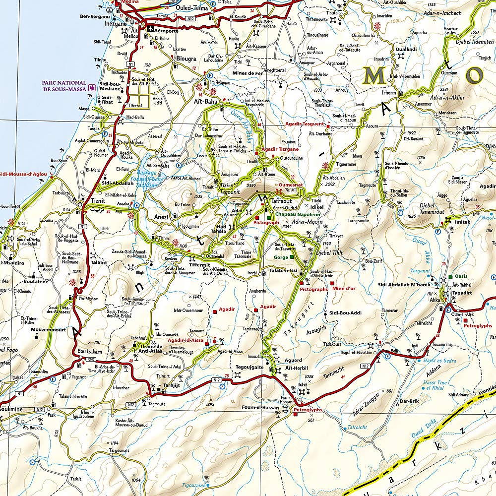
Designed for the intrepid traveller, National Geographic's Morocco Adventure Map blends exceptional cartographic precision with the rugged durability required for serious exploration. Whether you’re venturing into the labyrinthine streets of Fez, traversing the Atlas Mountains, or navigating the vast dunes of the Sahara, this map provides the clarity and coverage you need.
Split across two detailed sides, the map presents Morocco in its entirety, plus a large inset of the Western Sahara, offering both practical navigation and rich geographical context.
🧭 Key Features
| Feature | Description |
|---|---|
| 🛣️ Detailed Road Network | Clearly marked motorways, highways, main roads, and off-road trails with distance markers and travel designations. |
| 🏙️ City & Town Locations | Includes major cities such as Tangier, Tetouan, Fez, Rabat, Casablanca, Marrakesh, and more. Towns and villages are indexed for quick lookup. |
| 🏞️ Natural Landmarks | Features National Parks, mountain ranges, desert regions, oases, and protected areas. |
| 🗺️ Inset Map of Western Sahara | The reverse side includes expanded detail of this politically significant and sparsely populated area. |
| 🧾 Tourist Information | Highlights hundreds of points of interest: historical sites, scenic routes, ancient medinas, coastal highlights, and hiking routes. |
| 🌦️ Topographical Shading | Elevation is illustrated using hypsometric tinting and contour lines for a better sense of terrain. |
| 📌 Durable Material | Printed on synthetic paper – waterproof, tear-resistant, lightweight, and perfect for outdoor use. |
🧳 Who’s This Map For?
-
🧭 Backpackers & Overlanders – plan long-distance journeys or spontaneous side trips
-
🧳 Adventure Travellers – great for hiking, cycling, and road-tripping across diverse terrain
-
📚 Educators & Students – ideal for learning Moroccan geography, regions, and road systems
-
✈️ Holidaymakers – compact and user-friendly, with a wealth of information for short or long stays
📌 North & South – A Country in Full
-
Side One:
Northern Morocco — including the Mediterranean Coast, Rif Mountains, and cities like Tangier, Tetouan, Fez, Rabat, Casablanca, and Marrakesh. -
Side Two:
Southern Morocco — the Atlas Mountains, Sahara Desert, Draa Valley, and an inset of Western Sahara for extended exploration.
🏆 Why Choose National Geographic Maps?
-
✔️ Trusted cartography from one of the world’s most respected geographic institutions
-
✔️ Designed for travel – not just display
-
✔️ Durable synthetic paper withstands folding, stuffing, and rough use
-
✔️ Exceptional clarity and visual design
📦 Product Summary
| Specification | Detail |
|---|---|
| Map Title | Morocco Adventure Map – National Geographic |
| Scale | Approx. 1:1,000,000 |
| Format | Folded, two-sided |
| Material | Waterproof, tear-resistant synthetic |
| Folded Size | 235 x 108 mm |
| Unfolded Size | 965 x 660 mm |
| Includes | Inset of Western Sahara, place index, road distances, POIs |
🛒 Ready to Navigate North Africa?
Whether you’re heading to Chefchaouen’s blue streets, hiking through Imlil in the High Atlas, or crossing dunes in Erg Chebbi, this Morocco Adventure Map is your essential travel companion.
Order now and bring the insight of National Geographic with you, wherever your Moroccan journey leads.

Details & Craftsmanship
Every detail has been carefully considered to bring you the perfect product.

Details & Craftsmanship
Every detail has been carefully considered to bring you the perfect product.

Details & Craftsmanship
Every detail has been carefully considered to bring you the perfect product.
Details & Craftsmanship
Every detail has been carefully considered to bring you the perfect product.
Description
Publisher: National Geographic
Edition: Adventure Map Series
Format: Folded, two-sided map
Scale: 1:1,000,000 (approx.)
Folded Size: 235 mm x 108 mm
Unfolded Size: 965 mm x 660 mm
Material: Waterproof, tear-resistant synthetic paper
🌍 Explore Morocco with the Confidence of National Geographic Cartography
Designed for the intrepid traveller, National Geographic's Morocco Adventure Map blends exceptional cartographic precision with the rugged durability required for serious exploration. Whether you’re venturing into the labyrinthine streets of Fez, traversing the Atlas Mountains, or navigating the vast dunes of the Sahara, this map provides the clarity and coverage you need.
Split across two detailed sides, the map presents Morocco in its entirety, plus a large inset of the Western Sahara, offering both practical navigation and rich geographical context.
🧭 Key Features
| Feature | Description |
|---|---|
| 🛣️ Detailed Road Network | Clearly marked motorways, highways, main roads, and off-road trails with distance markers and travel designations. |
| 🏙️ City & Town Locations | Includes major cities such as Tangier, Tetouan, Fez, Rabat, Casablanca, Marrakesh, and more. Towns and villages are indexed for quick lookup. |
| 🏞️ Natural Landmarks | Features National Parks, mountain ranges, desert regions, oases, and protected areas. |
| 🗺️ Inset Map of Western Sahara | The reverse side includes expanded detail of this politically significant and sparsely populated area. |
| 🧾 Tourist Information | Highlights hundreds of points of interest: historical sites, scenic routes, ancient medinas, coastal highlights, and hiking routes. |
| 🌦️ Topographical Shading | Elevation is illustrated using hypsometric tinting and contour lines for a better sense of terrain. |
| 📌 Durable Material | Printed on synthetic paper – waterproof, tear-resistant, lightweight, and perfect for outdoor use. |
🧳 Who’s This Map For?
-
🧭 Backpackers & Overlanders – plan long-distance journeys or spontaneous side trips
-
🧳 Adventure Travellers – great for hiking, cycling, and road-tripping across diverse terrain
-
📚 Educators & Students – ideal for learning Moroccan geography, regions, and road systems
-
✈️ Holidaymakers – compact and user-friendly, with a wealth of information for short or long stays
📌 North & South – A Country in Full
-
Side One:
Northern Morocco — including the Mediterranean Coast, Rif Mountains, and cities like Tangier, Tetouan, Fez, Rabat, Casablanca, and Marrakesh. -
Side Two:
Southern Morocco — the Atlas Mountains, Sahara Desert, Draa Valley, and an inset of Western Sahara for extended exploration.
🏆 Why Choose National Geographic Maps?
-
✔️ Trusted cartography from one of the world’s most respected geographic institutions
-
✔️ Designed for travel – not just display
-
✔️ Durable synthetic paper withstands folding, stuffing, and rough use
-
✔️ Exceptional clarity and visual design
📦 Product Summary
| Specification | Detail |
|---|---|
| Map Title | Morocco Adventure Map – National Geographic |
| Scale | Approx. 1:1,000,000 |
| Format | Folded, two-sided |
| Material | Waterproof, tear-resistant synthetic |
| Folded Size | 235 x 108 mm |
| Unfolded Size | 965 x 660 mm |
| Includes | Inset of Western Sahara, place index, road distances, POIs |
🛒 Ready to Navigate North Africa?
Whether you’re heading to Chefchaouen’s blue streets, hiking through Imlil in the High Atlas, or crossing dunes in Erg Chebbi, this Morocco Adventure Map is your essential travel companion.
Order now and bring the insight of National Geographic with you, wherever your Moroccan journey leads.