Kazakhstan ITMB Map
HomeStore

Kazakhstan ITMB Map

Kazakhstan ITMB Map

Select Finish
From $6.07

Original: $17.34

-65%
Kazakhstan ITMB Mapโ€”

$17.34

$6.07

The Story

Kazakhstan โ€” ITMB Double-Sided Travel & Road Map

Spanning from the Caspian Sea to the high ranges near China, Kazakhstan is one of the worldโ€™s great frontier destinations. Immense open steppes, Silk Road heritage, modern cities and dramatic mountain landscapes make it a compelling country for independent exploration.

This ITMB double-sided Kazakhstan map delivers full national coverage in a large, practical format โ€” ideal for long-distance planning, overland routes and regional travel across Central Asia.


๐ŸŒ National Coverage โ€” Cleverly Divided

Because Kazakhstan is so vast, ITMB has split the country across two clear panels:

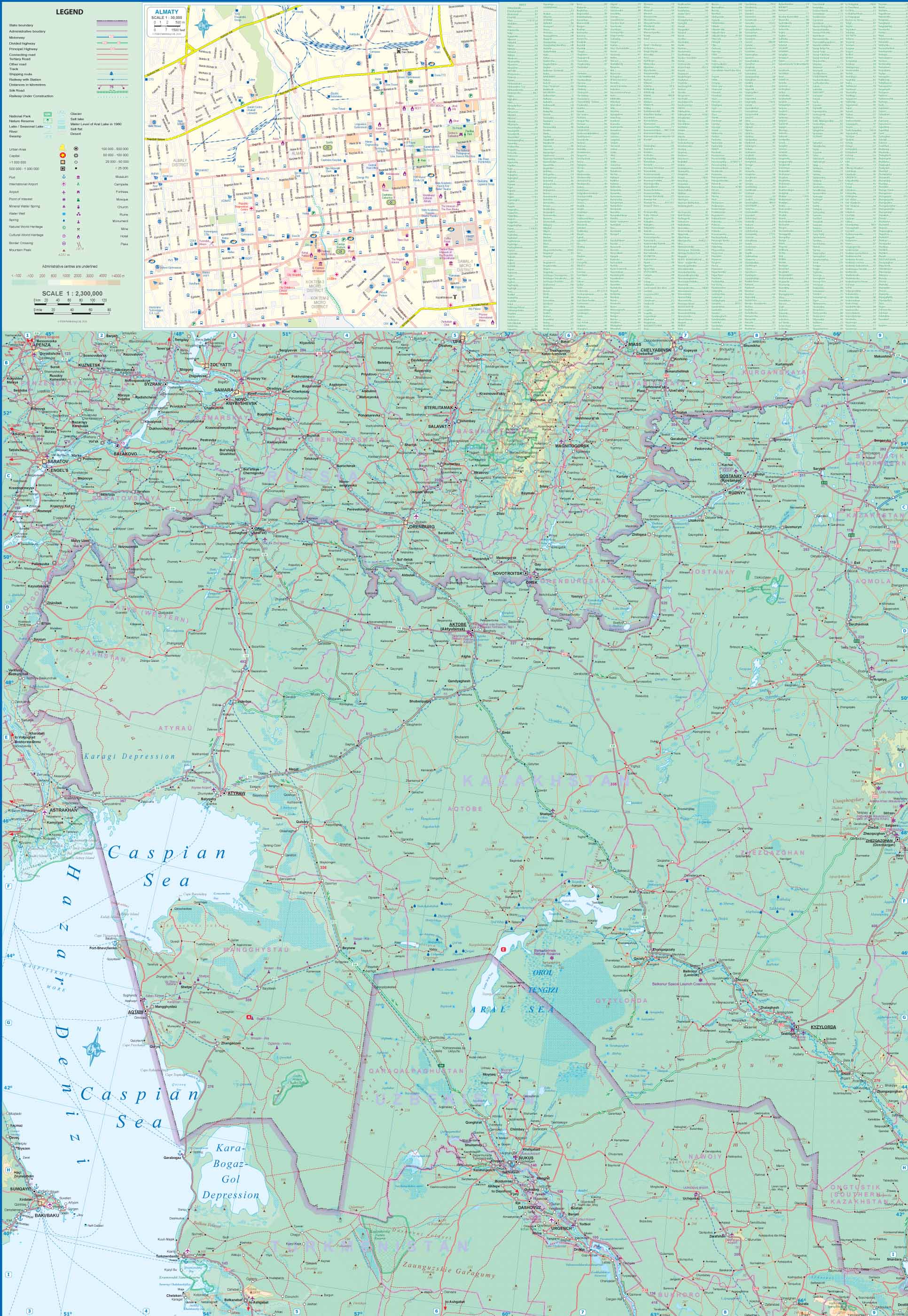
๐Ÿ—บ๏ธ Side One โ€” Western Kazakhstan

  • Caspian Sea coastline near Aktau

  • Western steppe regions

  • Industrial and historic centres

  • Remnants of the Aral Sea basin

  • Key road corridors toward Russia and Uzbekistan

๐Ÿ—บ๏ธ Side Two โ€” Eastern Kazakhstan

  • Central plateau and eastern territories

  • Mountain regions near China and the Altai

  • Silk Road transit corridors

  • Major cities including Almaty

The two sides overlap slightly, allowing seamless route continuity when crossing between panels.


๐Ÿš— Detailed Road & Transport Network

Travelling Kazakhstan means covering long distances. This map provides:

โœ”๏ธ Major highways and upgraded motorways
โœ”๏ธ Secondary and regional roads
โœ”๏ธ Remote steppe connectors
โœ”๏ธ Railways
โœ”๏ธ Airports
โœ”๏ธ Border crossings with Russia, China, Kyrgyzstan and Uzbekistan

Road classifications are clearly marked, helping drivers distinguish between high-speed corridors and more rural routes.


๐Ÿ™๏ธ Detailed Almaty Inset

A dedicated inset map of central Almaty offers:

๐Ÿ“ Street-level clarity
๐Ÿ›๏ธ Key landmarks
๐Ÿš— Urban access routes
๐Ÿงญ Orientation within the metropolitan area

Almaty sits strategically along historic Silk Road routes and near the Kyrgyz border, making it a logical starting or finishing point for many journeys.


๐Ÿž๏ธ Geographic & Scenic Context

The map highlights Kazakhstanโ€™s diverse landscapes, including:

  • The Caspian shoreline

  • Steppe grasslands

  • Desert zones

  • River systems

  • Mountain ranges including the Tian Shan and Altai

This geographic context is particularly useful for travellers planning scenic detours, trekking extensions or cross-border expeditions.


๐Ÿ“ Full Specifications

Feature Detail
Publisher ITMB โ€” International Travel Maps
Coverage Entire Republic of Kazakhstan
Scale Approx. 1 : 2,300,000
Format Double-sided folded map
Unfolded Size 690 mm ร— 1000 mm
Paper Waterproof, tear-resistant stock
Inset Central Almaty
Language English legend and place names

At 690 mm ร— 1000 mm, this is a generous wall-sized map when fully opened โ€” allowing the countryโ€™s immense geography to be shown clearly without crowding.

The waterproof, tear-resistant stock makes it suitable for use in vehicles and field conditions.


๐Ÿงญ Ideal For

๐Ÿš— Overlanders crossing Central Asia
๐ŸŒ Silk Road travellers
๐Ÿ—บ๏ธ Independent road-trippers
๐Ÿ•๏ธ Expedition planners
๐Ÿ“ Travellers wanting reliable offline navigation

Kazakhstanโ€™s distances are substantial, and mobile coverage can be inconsistent outside major cities. A large-scale paper map provides invaluable situational awareness.


โญ Explore the Heart of Central Asia

Kazakhstan sits at the crossroads of Europe and Asia โ€” culturally layered, geographically immense and increasingly accessible.

With the ITMB Kazakhstan Map, you gain:

โœ”๏ธ Complete national coverage
โœ”๏ธ Updated infrastructure
โœ”๏ธ Clear regional division
โœ”๏ธ Detailed capital inset
โœ”๏ธ Large, legible format
โœ”๏ธ Durable travel-ready construction

Unfold it across your table, trace your route from the Caspian coast to the Chinese frontier, and explore one of the worldโ€™s largest countries with confidence and clarity.

Kazakhstan ITMB Map - Image 2

Details & Craftsmanship

Every detail has been carefully considered to bring you the perfect product.

Kazakhstan ITMB Map - Image 3

Details & Craftsmanship

Every detail has been carefully considered to bring you the perfect product.

Description

Kazakhstan โ€” ITMB Double-Sided Travel & Road Map

Spanning from the Caspian Sea to the high ranges near China, Kazakhstan is one of the worldโ€™s great frontier destinations. Immense open steppes, Silk Road heritage, modern cities and dramatic mountain landscapes make it a compelling country for independent exploration.

This ITMB double-sided Kazakhstan map delivers full national coverage in a large, practical format โ€” ideal for long-distance planning, overland routes and regional travel across Central Asia.


๐ŸŒ National Coverage โ€” Cleverly Divided

Because Kazakhstan is so vast, ITMB has split the country across two clear panels:

๐Ÿ—บ๏ธ Side One โ€” Western Kazakhstan

  • Caspian Sea coastline near Aktau

  • Western steppe regions

  • Industrial and historic centres

  • Remnants of the Aral Sea basin

  • Key road corridors toward Russia and Uzbekistan

๐Ÿ—บ๏ธ Side Two โ€” Eastern Kazakhstan

  • Central plateau and eastern territories

  • Mountain regions near China and the Altai

  • Silk Road transit corridors

  • Major cities including Almaty

The two sides overlap slightly, allowing seamless route continuity when crossing between panels.


๐Ÿš— Detailed Road & Transport Network

Travelling Kazakhstan means covering long distances. This map provides:

โœ”๏ธ Major highways and upgraded motorways
โœ”๏ธ Secondary and regional roads
โœ”๏ธ Remote steppe connectors
โœ”๏ธ Railways
โœ”๏ธ Airports
โœ”๏ธ Border crossings with Russia, China, Kyrgyzstan and Uzbekistan

Road classifications are clearly marked, helping drivers distinguish between high-speed corridors and more rural routes.


๐Ÿ™๏ธ Detailed Almaty Inset

A dedicated inset map of central Almaty offers:

๐Ÿ“ Street-level clarity
๐Ÿ›๏ธ Key landmarks
๐Ÿš— Urban access routes
๐Ÿงญ Orientation within the metropolitan area

Almaty sits strategically along historic Silk Road routes and near the Kyrgyz border, making it a logical starting or finishing point for many journeys.


๐Ÿž๏ธ Geographic & Scenic Context

The map highlights Kazakhstanโ€™s diverse landscapes, including:

  • The Caspian shoreline

  • Steppe grasslands

  • Desert zones

  • River systems

  • Mountain ranges including the Tian Shan and Altai

This geographic context is particularly useful for travellers planning scenic detours, trekking extensions or cross-border expeditions.


๐Ÿ“ Full Specifications

Feature Detail
Publisher ITMB โ€” International Travel Maps
Coverage Entire Republic of Kazakhstan
Scale Approx. 1 : 2,300,000
Format Double-sided folded map
Unfolded Size 690 mm ร— 1000 mm
Paper Waterproof, tear-resistant stock
Inset Central Almaty
Language English legend and place names

At 690 mm ร— 1000 mm, this is a generous wall-sized map when fully opened โ€” allowing the countryโ€™s immense geography to be shown clearly without crowding.

The waterproof, tear-resistant stock makes it suitable for use in vehicles and field conditions.


๐Ÿงญ Ideal For

๐Ÿš— Overlanders crossing Central Asia
๐ŸŒ Silk Road travellers
๐Ÿ—บ๏ธ Independent road-trippers
๐Ÿ•๏ธ Expedition planners
๐Ÿ“ Travellers wanting reliable offline navigation

Kazakhstanโ€™s distances are substantial, and mobile coverage can be inconsistent outside major cities. A large-scale paper map provides invaluable situational awareness.


โญ Explore the Heart of Central Asia

Kazakhstan sits at the crossroads of Europe and Asia โ€” culturally layered, geographically immense and increasingly accessible.

With the ITMB Kazakhstan Map, you gain:

โœ”๏ธ Complete national coverage
โœ”๏ธ Updated infrastructure
โœ”๏ธ Clear regional division
โœ”๏ธ Detailed capital inset
โœ”๏ธ Large, legible format
โœ”๏ธ Durable travel-ready construction

Unfold it across your table, trace your route from the Caspian coast to the Chinese frontier, and explore one of the worldโ€™s largest countries with confidence and clarity.
Kazakhstan ITMB Map | Mapworld