Children's Europe Wall Map by Collins 760 x 492mm
HomeStore

Children's Europe Wall Map by Collins 760 x 492mm

Children's Europe Wall Map by Collins 760 x 492mm

Select Finish
From $17.02

Original: $48.62

-65%
Children's Europe Wall Map by Collins 760 x 492mm

$48.62

$17.02

The Story

Children’s Europe Wall Map by Collins (Illustrated by Steve Evans)

760 × 492 mm • Paper / Laminated / Laminated + Hang Rails / Canvas / Canvas + Hang Rails • Made in Australia

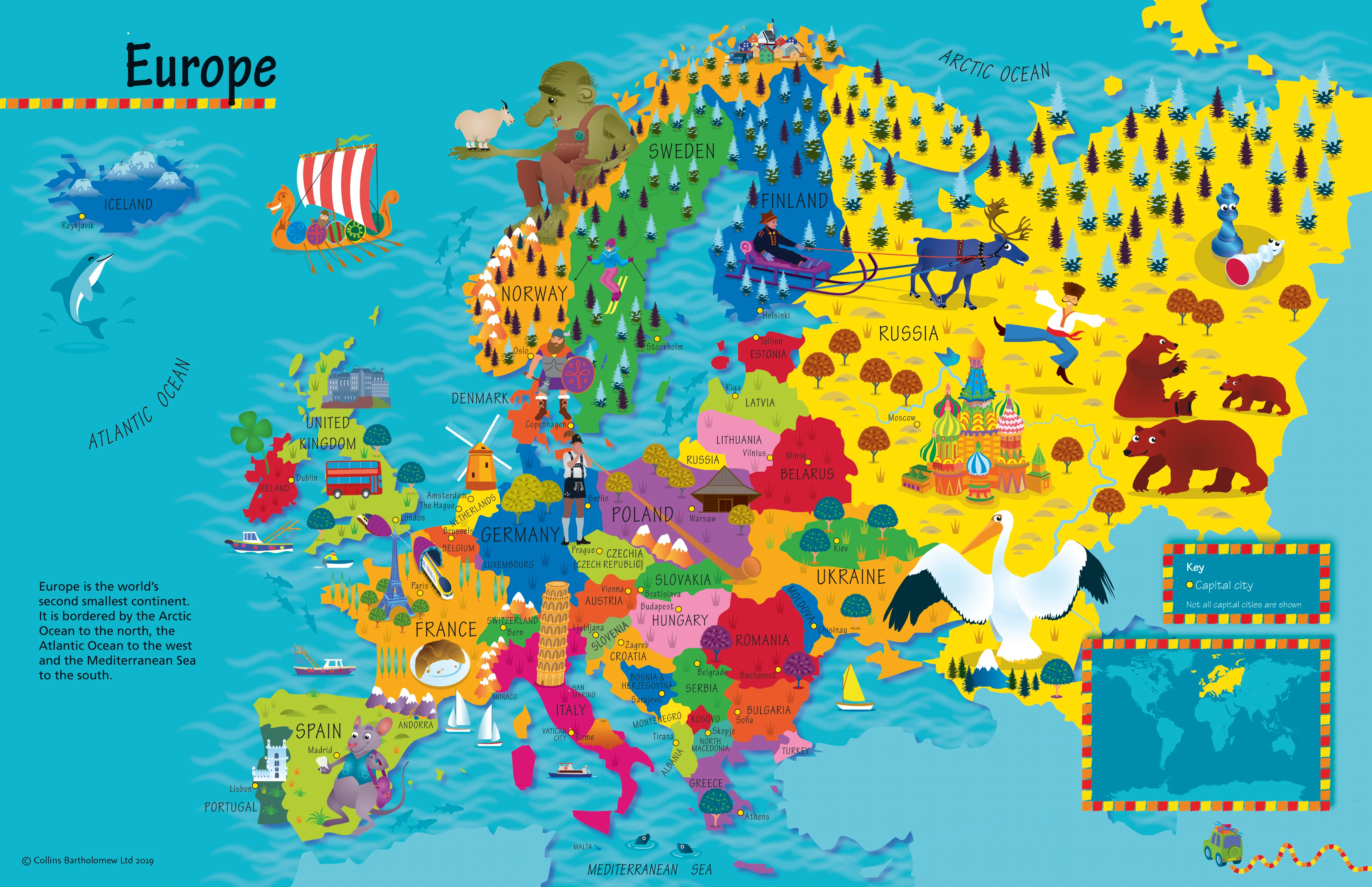
Turn your wall into a launchpad for curiosity. This beautifully illustrated Collins map—drawn by Steve Evans—mixes bright, child-friendly cartography with playful artwork so young learners (ages 4–8) can explore Europe’s countries, capitals, cultures, animals, foods, and landmarks at a glance.


🌟 What’s on the Map

  • 🗺️ Countries & capitals clearly labelled for easy recognition

  • 🐾 Pictorial icons for wildlife, famous buildings, sports, foods & traditions

  • 🧭 Compass & simple legend to build early map skills

  • 🌊 Major seas & islands for geographic context

  • 🧒 Kid-first design: large, legible labels; balanced colours; clutter-free layout


Why Kids Love It (and Teachers Do, Too)

  • Instant engagement: charming illustrations invite questions and storytelling

  • Visual memory: icons help children remember places and facts faster

  • Confidence-building: simple features (legend, compass) make maps feel approachable

  • Discussion-ready: perfect springboard for show-and-tell, class displays, and projects


Learning Outcomes (Ages 4–8)

  • Geography basics: continents vs. countries; capital recognition; cardinal directions

  • Cultural awareness: compare foods, animals, and landmarks across nations

  • Map skills: symbols, legends, spatial relationships, and simple routes

  • Vocabulary growth: place names, landforms, and everyday cultural words


Try These No-Prep Activities

  • Capital Match: “Find the capital of Spain… Poland… Norway.”

  • Landmark Hunt: “Spot the Eiffel Tower, Colosseum, windmill—what countries are they in?”

  • Animal Safari: “Find a bear, reindeer, eagle—where do they live?”

  • Food Trail: “Which countries are known for pizza, waffles, or paella?”

  • Passport Journey: Trace a pretend trip Portugal → France → Germany → Poland.


Where It Belongs

Classrooms, libraries, child-care centres, playrooms, bedrooms, learning nooks, GP/dentist waiting rooms, community hubs, homeschooling spaces.


🎨 Finishes & Display Options

  • 📄 Paper — FSC® 160 gsm Matte-Coated
    Smooth, low-glare stock ideal for framing under glass. Printed with archival Hewlett-Packard pigment inks for excellent fade resistance and crisp colour.

  • 💧 Laminated — True Encapsulation
    Printed on 120 gsm and sealed in 2 × 80-micron gloss laminate (edge-sealed).
    Wipe-clean, tear-resistant, moisture-safe. Use non-permanent whiteboard markers and map dots.

  • 🪵 Laminated + Timber Hang Rails — Ready to Hang
    Natural lacquered timber rails (top & bottom) with top hanging cord for a clean, frame-free display.
    ⏱️ Custom finish—please allow up to 10 working days for rail fitting.

  • 🖼️ Canvas — HP 395 gsm Professional Matte
    Gallery-grade canvas + archival HP pigment inks for rich detail and long-term fade resistance. Low-glare, tactile surface.

  • 🪵 Canvas + Timber Hang Rails
    The same premium canvas, finished with natural timber rails + top hanging cordready to hang.
    ⏱️ Custom finish—please allow up to 10 working days for rail fitting.

Dry-erase markers are recommended only on laminated versions.


📐 Specifications

Attribute Details
Title Children’s Europe Wall Map by Collins
Illustrator Steve Evans
Size 760 mm (W) × 492 mm (H)
Audience Ages 4–8
Content Countries, capitals, icons (animals, foods, landmarks, sports, culture)
Formats Paper • Laminated • Laminated + Hang Rails • Canvas • Canvas + Hang Rails
Printing Archival HP pigment inks (fade-resistant)
Paper FSC® 160 gsm matte-coated
Canvas HP 395 gsm Professional Matte
Origin Made in Australia

Care Tips

  • Laminated: Use non-permanent whiteboard markers; wipe with a dry microfiber cloth (lightly damp if needed).

  • Paper: Frame under glass to protect the print surface.

  • Canvas: Dust gently; avoid liquids and prolonged direct sunlight.


🎁 Gift-Ready

A thoughtful present for birthdays, classrooms, and new playrooms—pairs beautifully with a globe or children’s atlas.


🤝 Our Commitment

  • Local craftsmanship: Printed and finished in Australia for consistent quality.

  • Sustainable choices: FSC® papers and long-life HP pigment inks reduce waste and maximise longevity.

  • Clarity first: Legends, colours, and label hierarchies tuned for kid-friendly readability.

  • Packed with care: Each map is hand-checked and securely boxed to arrive clean and display-ready.


Bring Europe to their wall—bright, friendly, and endlessly explorable. Choose your finish and make geography the favourite subject at home or school.

Description

Children’s Europe Wall Map by Collins (Illustrated by Steve Evans)

760 × 492 mm • Paper / Laminated / Laminated + Hang Rails / Canvas / Canvas + Hang Rails • Made in Australia

Turn your wall into a launchpad for curiosity. This beautifully illustrated Collins map—drawn by Steve Evans—mixes bright, child-friendly cartography with playful artwork so young learners (ages 4–8) can explore Europe’s countries, capitals, cultures, animals, foods, and landmarks at a glance.


🌟 What’s on the Map

  • 🗺️ Countries & capitals clearly labelled for easy recognition

  • 🐾 Pictorial icons for wildlife, famous buildings, sports, foods & traditions

  • 🧭 Compass & simple legend to build early map skills

  • 🌊 Major seas & islands for geographic context

  • 🧒 Kid-first design: large, legible labels; balanced colours; clutter-free layout


Why Kids Love It (and Teachers Do, Too)

  • Instant engagement: charming illustrations invite questions and storytelling

  • Visual memory: icons help children remember places and facts faster

  • Confidence-building: simple features (legend, compass) make maps feel approachable

  • Discussion-ready: perfect springboard for show-and-tell, class displays, and projects


Learning Outcomes (Ages 4–8)

  • Geography basics: continents vs. countries; capital recognition; cardinal directions

  • Cultural awareness: compare foods, animals, and landmarks across nations

  • Map skills: symbols, legends, spatial relationships, and simple routes

  • Vocabulary growth: place names, landforms, and everyday cultural words


Try These No-Prep Activities

  • Capital Match: “Find the capital of Spain… Poland… Norway.”

  • Landmark Hunt: “Spot the Eiffel Tower, Colosseum, windmill—what countries are they in?”

  • Animal Safari: “Find a bear, reindeer, eagle—where do they live?”

  • Food Trail: “Which countries are known for pizza, waffles, or paella?”

  • Passport Journey: Trace a pretend trip Portugal → France → Germany → Poland.


Where It Belongs

Classrooms, libraries, child-care centres, playrooms, bedrooms, learning nooks, GP/dentist waiting rooms, community hubs, homeschooling spaces.


🎨 Finishes & Display Options

  • 📄 Paper — FSC® 160 gsm Matte-Coated
    Smooth, low-glare stock ideal for framing under glass. Printed with archival Hewlett-Packard pigment inks for excellent fade resistance and crisp colour.

  • 💧 Laminated — True Encapsulation
    Printed on 120 gsm and sealed in 2 × 80-micron gloss laminate (edge-sealed).
    Wipe-clean, tear-resistant, moisture-safe. Use non-permanent whiteboard markers and map dots.

  • 🪵 Laminated + Timber Hang Rails — Ready to Hang
    Natural lacquered timber rails (top & bottom) with top hanging cord for a clean, frame-free display.
    ⏱️ Custom finish—please allow up to 10 working days for rail fitting.

  • 🖼️ Canvas — HP 395 gsm Professional Matte
    Gallery-grade canvas + archival HP pigment inks for rich detail and long-term fade resistance. Low-glare, tactile surface.

  • 🪵 Canvas + Timber Hang Rails
    The same premium canvas, finished with natural timber rails + top hanging cordready to hang.
    ⏱️ Custom finish—please allow up to 10 working days for rail fitting.

Dry-erase markers are recommended only on laminated versions.


📐 Specifications

Attribute Details
Title Children’s Europe Wall Map by Collins
Illustrator Steve Evans
Size 760 mm (W) × 492 mm (H)
Audience Ages 4–8
Content Countries, capitals, icons (animals, foods, landmarks, sports, culture)
Formats Paper • Laminated • Laminated + Hang Rails • Canvas • Canvas + Hang Rails
Printing Archival HP pigment inks (fade-resistant)
Paper FSC® 160 gsm matte-coated
Canvas HP 395 gsm Professional Matte
Origin Made in Australia

Care Tips

  • Laminated: Use non-permanent whiteboard markers; wipe with a dry microfiber cloth (lightly damp if needed).

  • Paper: Frame under glass to protect the print surface.

  • Canvas: Dust gently; avoid liquids and prolonged direct sunlight.


🎁 Gift-Ready

A thoughtful present for birthdays, classrooms, and new playrooms—pairs beautifully with a globe or children’s atlas.


🤝 Our Commitment

  • Local craftsmanship: Printed and finished in Australia for consistent quality.

  • Sustainable choices: FSC® papers and long-life HP pigment inks reduce waste and maximise longevity.

  • Clarity first: Legends, colours, and label hierarchies tuned for kid-friendly readability.

  • Packed with care: Each map is hand-checked and securely boxed to arrive clean and display-ready.


Bring Europe to their wall—bright, friendly, and endlessly explorable. Choose your finish and make geography the favourite subject at home or school.

Children's Europe Wall Map by Collins 760 x 492mm | Mapworld