Original: $41.67
-65%$41.67
$14.58The Story
🚤 Broads National Park Map – Collins
Your Essential Guide to England’s Waterland Wonderland
Size: 810 mm (W) x 560 mm (H)
Scale: 1:191,000
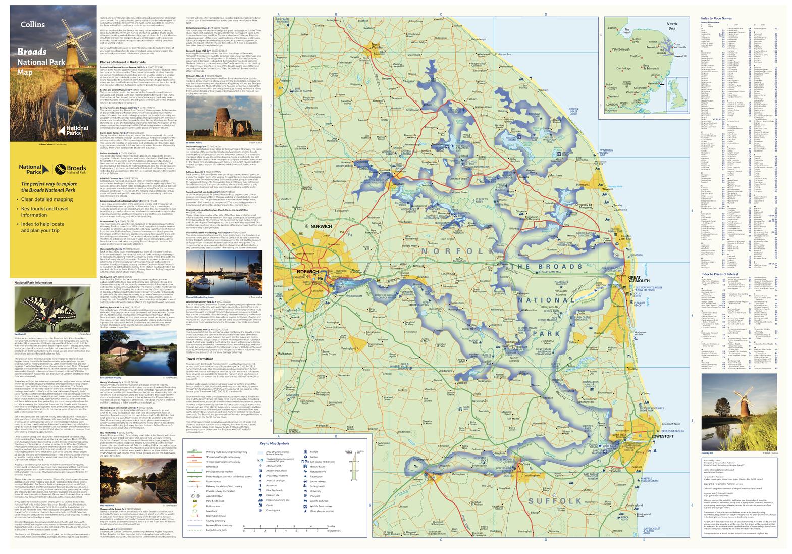
Discover the serene beauty and unique waterways of the Broads National Park with this expertly detailed map by Collins. Whether you’re cruising through tranquil reed-lined rivers, cycling past windmills, or exploring waterside villages, this map is your perfect guide to one of Britain’s most enchanting landscapes.
🗺️ A Map That Brings the Broads to Life
Crafted for adventurers, holidaymakers, and nature lovers alike, this full-colour map includes:
-
🌊 Detailed navigation of rivers, broads, and channels within the park
-
🚤 Popular boating and mooring points
-
🗽 Tourist highlights – heritage windmills, museums, gardens, and nature reserves
-
🛶 Walking and cycling routes through peaceful fenlands
-
📷 Photographic insets of iconic locations and scenic views
-
🧭 Essential travel information including park centres and major access roads
This map beautifully balances cartographic accuracy with visual appeal—making it a joy to plan your journey and a pleasure to display.
📍 Explore One of Britain’s Hidden Gems
The Broads National Park in Eastern England is a labyrinth of rivers and lakes, winding through Norfolk and Suffolk. It’s home to more than 125 miles of navigable waterways, rare birdlife, wildflowers, and charming market towns.
From the windmill-dotted skies of Thurne to the peaceful inlets of Hickling Broad, this region is a sanctuary for slow travel, outdoor adventure, and quiet reflection. With the Collins Broads map in hand, you’ll never miss a moment—or a mooring.
🖨️ Format Options
Choose your ideal format—whether for planning, adventure, or décor:
| Format | Description |
|---|---|
| 📄 Paper (160 gsm) | Printed on heavyweight coated paper—perfect for framing or folding for the boat or backpack. |
| 🧽 Laminated (Encapsulated) | Fully encapsulated in durable 80-micron gloss laminate—ideal for marking routes with whiteboard pens and wiping clean. |
| 🪵 Laminated with Wooden Hang Rails | Elegantly mounted with natural timber rails and top cord—ready to hang in your holiday home or waterside retreat. |
| 🖼️ Canvas (395 gsm Matte) | Printed on fine-art quality canvas with pigment inks—rich, fade-resistant, and textured for premium presentation. |
| 🪵 Canvas with Wooden Hang Rails | The ultimate display option, with hand-fitted timber rails—bringing rustic warmth to any room or gallery wall. |
⏳ Please allow up to 10 working days for framed hang-rail formats as each piece is made to order by our specialist framer.
🎁 A Thoughtful Gift for:
-
🚤 Boating enthusiasts and holidaymakers
-
🌿 Lovers of English countryside and waterways
-
🏡 Homeowners with a nautical or vintage theme
-
📚 Educators and geography classrooms
-
🎁 Thoughtful housewarming or travel gifts
⚓ Navigate, Explore, Display
Whether you're charting your next boating holiday, reliving past travels, or simply admiring the elegance of East Anglia’s waterways, the Broads National Park Map by Collins is a beautiful and practical addition to your collection.
Plan it. Frame it. Treasure it.
Description
🚤 Broads National Park Map – Collins
Your Essential Guide to England’s Waterland Wonderland
Size: 810 mm (W) x 560 mm (H)
Scale: 1:191,000
Discover the serene beauty and unique waterways of the Broads National Park with this expertly detailed map by Collins. Whether you’re cruising through tranquil reed-lined rivers, cycling past windmills, or exploring waterside villages, this map is your perfect guide to one of Britain’s most enchanting landscapes.
🗺️ A Map That Brings the Broads to Life
Crafted for adventurers, holidaymakers, and nature lovers alike, this full-colour map includes:
-
🌊 Detailed navigation of rivers, broads, and channels within the park
-
🚤 Popular boating and mooring points
-
🗽 Tourist highlights – heritage windmills, museums, gardens, and nature reserves
-
🛶 Walking and cycling routes through peaceful fenlands
-
📷 Photographic insets of iconic locations and scenic views
-
🧭 Essential travel information including park centres and major access roads
This map beautifully balances cartographic accuracy with visual appeal—making it a joy to plan your journey and a pleasure to display.
📍 Explore One of Britain’s Hidden Gems
The Broads National Park in Eastern England is a labyrinth of rivers and lakes, winding through Norfolk and Suffolk. It’s home to more than 125 miles of navigable waterways, rare birdlife, wildflowers, and charming market towns.
From the windmill-dotted skies of Thurne to the peaceful inlets of Hickling Broad, this region is a sanctuary for slow travel, outdoor adventure, and quiet reflection. With the Collins Broads map in hand, you’ll never miss a moment—or a mooring.
🖨️ Format Options
Choose your ideal format—whether for planning, adventure, or décor:
| Format | Description |
|---|---|
| 📄 Paper (160 gsm) | Printed on heavyweight coated paper—perfect for framing or folding for the boat or backpack. |
| 🧽 Laminated (Encapsulated) | Fully encapsulated in durable 80-micron gloss laminate—ideal for marking routes with whiteboard pens and wiping clean. |
| 🪵 Laminated with Wooden Hang Rails | Elegantly mounted with natural timber rails and top cord—ready to hang in your holiday home or waterside retreat. |
| 🖼️ Canvas (395 gsm Matte) | Printed on fine-art quality canvas with pigment inks—rich, fade-resistant, and textured for premium presentation. |
| 🪵 Canvas with Wooden Hang Rails | The ultimate display option, with hand-fitted timber rails—bringing rustic warmth to any room or gallery wall. |
⏳ Please allow up to 10 working days for framed hang-rail formats as each piece is made to order by our specialist framer.
🎁 A Thoughtful Gift for:
-
🚤 Boating enthusiasts and holidaymakers
-
🌿 Lovers of English countryside and waterways
-
🏡 Homeowners with a nautical or vintage theme
-
📚 Educators and geography classrooms
-
🎁 Thoughtful housewarming or travel gifts
⚓ Navigate, Explore, Display
Whether you're charting your next boating holiday, reliving past travels, or simply admiring the elegance of East Anglia’s waterways, the Broads National Park Map by Collins is a beautiful and practical addition to your collection.
Plan it. Frame it. Treasure it.