Original: $34.72
-65%$34.72
$12.15The Story
The definitive wall map for professionals, planners, educators and Adelaide locals alike.
Bring Adelaide into sharp focus with this meticulously detailed, double-sided laminated wall map—a powerful tool for visualising everything from local streets to the broader suburban sprawl. Whether you're managing property portfolios, running a mobile business, teaching geography, or simply passionate about your city, this map delivers precision, scale, and usability.
📍 Two Perspectives in One Map
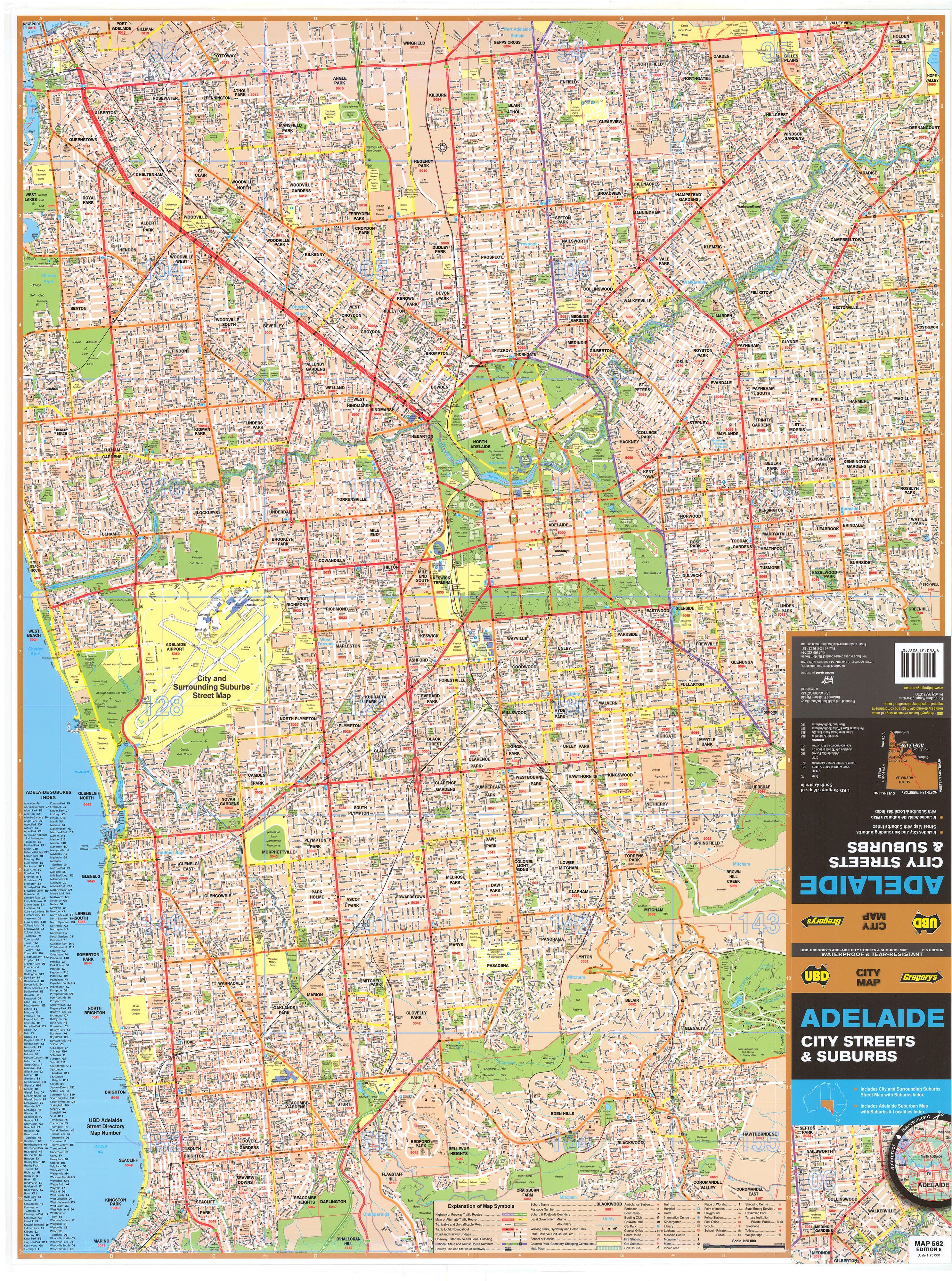
Front Side: Central Adelaide in Exceptional Detail
🧭 Scale: 1:25,000
The front side zooms in on Adelaide’s urban core, offering exceptional street-level detail within a 10-kilometre radius of the city centre. This view covers:
-
🏙️ City landmarks, CBD streets, and government precincts
-
🌳 Parks and green spaces like Botanic Park and Victoria Park
-
🚗 Every road and laneway clearly marked for easy navigation
-
🏘️ Key inner suburbs including Birkenhead, Holden Hill, Marino, and Coromandel East
Ideal for:
-
Real estate agencies managing inner-city listings
-
Urban developers and planners
-
Businesses offering city-wide services
-
Residents and city explorers
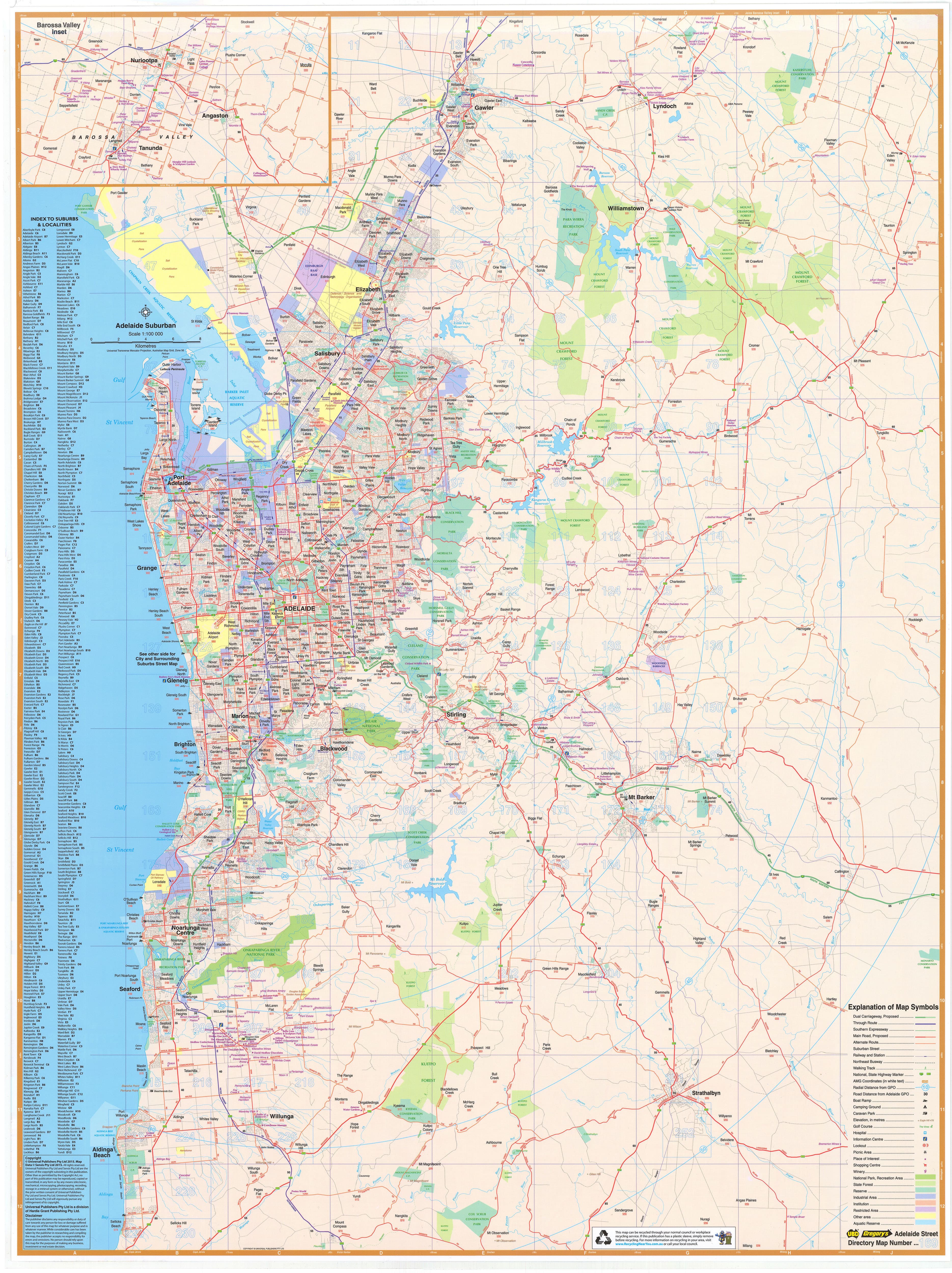
Reverse Side: The Greater Adelaide Region
🧭 Scale: 1:100,000
Flip the map over to see the broader suburban footprint of Adelaide—perfect for understanding the city’s layout beyond the CBD.
Key features:
-
🚙 Major arterial roads and highways
-
🏡 Clearly labelled suburb names with postcodes
-
🌲 National parks, protected areas, and coastal zones
-
🏭 Industrial precincts and logistics hubs
-
🍷 An inset of the Barossa Valley—ideal for tourism and wine-region planning
Covers a 75km radius of metropolitan Adelaide, stretching from Gawler in the north to Aldinga Beach in the south. Whether you're planning logistics, school catchments, or community engagement zones, this side offers a bird’s-eye view of how the city connects.
🏡 Designed for Multiple Uses
This map isn’t just beautiful—it’s practical, durable, and reusable, making it suitable for a range of purposes:
-
🏠 Home buyers visualising potential neighbourhoods
-
🚛 Courier and trades services planning delivery zones
-
🏢 Sales and marketing teams defining territories
-
🧑🏫 Teachers and lecturers delivering geography and urban planning lessons
-
🗂️ Corporate strategy sessions requiring visual aids
The double-sided format means you always have access to the right level of detail for your task, from local to regional.
✏️ Laminated for Long-Term Use
Encapsulated in high-quality gloss laminate, this map is:
-
✍️ Writable with whiteboard markers – annotate routes, circle properties, or plan service areas
-
🔁 Reusable and wipeable – simply clean with a soft cloth
-
💧 Stain-resistant – resists fingerprints, coffee spills, and accidental smudges
-
💪 Tear-resistant – built to last in busy office environments or classrooms
Printed using non-fade, pigment-based inks, the map retains vibrant colours and sharp text clarity for years, even with regular handling.
🖼️ Optional Timber Hang Rails – Simple, Elegant Display
Make a statement with our natural timber hang rail set, available for both practicality and style. This option transforms your map into a handsome wall feature, complete with:
-
🔨 Top and bottom wooden rollers (lacquered natural finish)
-
🧵 A pre-attached hanging cord – just add a wall hook and you’re done
Perfect for:
-
🏫 School walls and lecture theatres
-
🏢 Conference rooms and offices
-
🧑💼 Real estate and urban planning boards
-
🏡 Home studies and libraries
Please note: Allow up to 10 working days for delivery of the hang-railed version due to the careful assembly process.
🛍️ Purchase Options to Suit Every Need
| Option | Price | Description |
|---|---|---|
| Flat Laminated Map (UBD) | $99.00 | No fold lines, perfect for hanging or framing. Professional and clean. |
| Laminated Folded Map | $49.95 | Same map, but laminated after folding—creases visible, but fully functional. |
Both versions include full double-sided content and high-gloss lamination.
📐 Specifications at a Glance
-
🏷️ Publisher: UBD Gregory’s
-
📆 Edition: 2023
-
📏 Scales:
-
1:25,000 (Inner Adelaide)
-
1:100,000 (Greater Adelaide)
-
-
📐 Dimensions: 690 mm wide × 1000 mm high
-
🧾 Format: Laminated, double-sided (flat or folded)
-
🎨 Finish: Gloss encapsulation with pigment-based inks
✅ Why Choose This Map?
-
✅ Unmatched detail for Adelaide metro and suburbs
-
✅ Durable and professional-quality lamination
-
✅ Writable, reusable, and stain-resistant
-
✅ Available in budget or premium finishes
-
✅ Ideal for personal, academic, or professional use
This is more than just a map—it's a versatile, high-quality planning and reference tool, designed to support real-world decision-making with clarity and precision. From the hills to the coast, from postcode to parkland, this map puts the entire Adelaide region at your fingertips.
Details & Craftsmanship
Every detail has been carefully considered to bring you the perfect product.
Description
The definitive wall map for professionals, planners, educators and Adelaide locals alike.
Bring Adelaide into sharp focus with this meticulously detailed, double-sided laminated wall map—a powerful tool for visualising everything from local streets to the broader suburban sprawl. Whether you're managing property portfolios, running a mobile business, teaching geography, or simply passionate about your city, this map delivers precision, scale, and usability.
📍 Two Perspectives in One Map
Front Side: Central Adelaide in Exceptional Detail
🧭 Scale: 1:25,000
The front side zooms in on Adelaide’s urban core, offering exceptional street-level detail within a 10-kilometre radius of the city centre. This view covers:
-
🏙️ City landmarks, CBD streets, and government precincts
-
🌳 Parks and green spaces like Botanic Park and Victoria Park
-
🚗 Every road and laneway clearly marked for easy navigation
-
🏘️ Key inner suburbs including Birkenhead, Holden Hill, Marino, and Coromandel East
Ideal for:
-
Real estate agencies managing inner-city listings
-
Urban developers and planners
-
Businesses offering city-wide services
-
Residents and city explorers
Reverse Side: The Greater Adelaide Region
🧭 Scale: 1:100,000
Flip the map over to see the broader suburban footprint of Adelaide—perfect for understanding the city’s layout beyond the CBD.
Key features:
-
🚙 Major arterial roads and highways
-
🏡 Clearly labelled suburb names with postcodes
-
🌲 National parks, protected areas, and coastal zones
-
🏭 Industrial precincts and logistics hubs
-
🍷 An inset of the Barossa Valley—ideal for tourism and wine-region planning
Covers a 75km radius of metropolitan Adelaide, stretching from Gawler in the north to Aldinga Beach in the south. Whether you're planning logistics, school catchments, or community engagement zones, this side offers a bird’s-eye view of how the city connects.
🏡 Designed for Multiple Uses
This map isn’t just beautiful—it’s practical, durable, and reusable, making it suitable for a range of purposes:
-
🏠 Home buyers visualising potential neighbourhoods
-
🚛 Courier and trades services planning delivery zones
-
🏢 Sales and marketing teams defining territories
-
🧑🏫 Teachers and lecturers delivering geography and urban planning lessons
-
🗂️ Corporate strategy sessions requiring visual aids
The double-sided format means you always have access to the right level of detail for your task, from local to regional.
✏️ Laminated for Long-Term Use
Encapsulated in high-quality gloss laminate, this map is:
-
✍️ Writable with whiteboard markers – annotate routes, circle properties, or plan service areas
-
🔁 Reusable and wipeable – simply clean with a soft cloth
-
💧 Stain-resistant – resists fingerprints, coffee spills, and accidental smudges
-
💪 Tear-resistant – built to last in busy office environments or classrooms
Printed using non-fade, pigment-based inks, the map retains vibrant colours and sharp text clarity for years, even with regular handling.
🖼️ Optional Timber Hang Rails – Simple, Elegant Display
Make a statement with our natural timber hang rail set, available for both practicality and style. This option transforms your map into a handsome wall feature, complete with:
-
🔨 Top and bottom wooden rollers (lacquered natural finish)
-
🧵 A pre-attached hanging cord – just add a wall hook and you’re done
Perfect for:
-
🏫 School walls and lecture theatres
-
🏢 Conference rooms and offices
-
🧑💼 Real estate and urban planning boards
-
🏡 Home studies and libraries
Please note: Allow up to 10 working days for delivery of the hang-railed version due to the careful assembly process.
🛍️ Purchase Options to Suit Every Need
| Option | Price | Description |
|---|---|---|
| Flat Laminated Map (UBD) | $99.00 | No fold lines, perfect for hanging or framing. Professional and clean. |
| Laminated Folded Map | $49.95 | Same map, but laminated after folding—creases visible, but fully functional. |
Both versions include full double-sided content and high-gloss lamination.
📐 Specifications at a Glance
-
🏷️ Publisher: UBD Gregory’s
-
📆 Edition: 2023
-
📏 Scales:
-
1:25,000 (Inner Adelaide)
-
1:100,000 (Greater Adelaide)
-
-
📐 Dimensions: 690 mm wide × 1000 mm high
-
🧾 Format: Laminated, double-sided (flat or folded)
-
🎨 Finish: Gloss encapsulation with pigment-based inks
✅ Why Choose This Map?
-
✅ Unmatched detail for Adelaide metro and suburbs
-
✅ Durable and professional-quality lamination
-
✅ Writable, reusable, and stain-resistant
-
✅ Available in budget or premium finishes
-
✅ Ideal for personal, academic, or professional use
This is more than just a map—it's a versatile, high-quality planning and reference tool, designed to support real-world decision-making with clarity and precision. From the hills to the coast, from postcode to parkland, this map puts the entire Adelaide region at your fingertips.