Original: $41.67
-65%$41.67
$14.58The Story
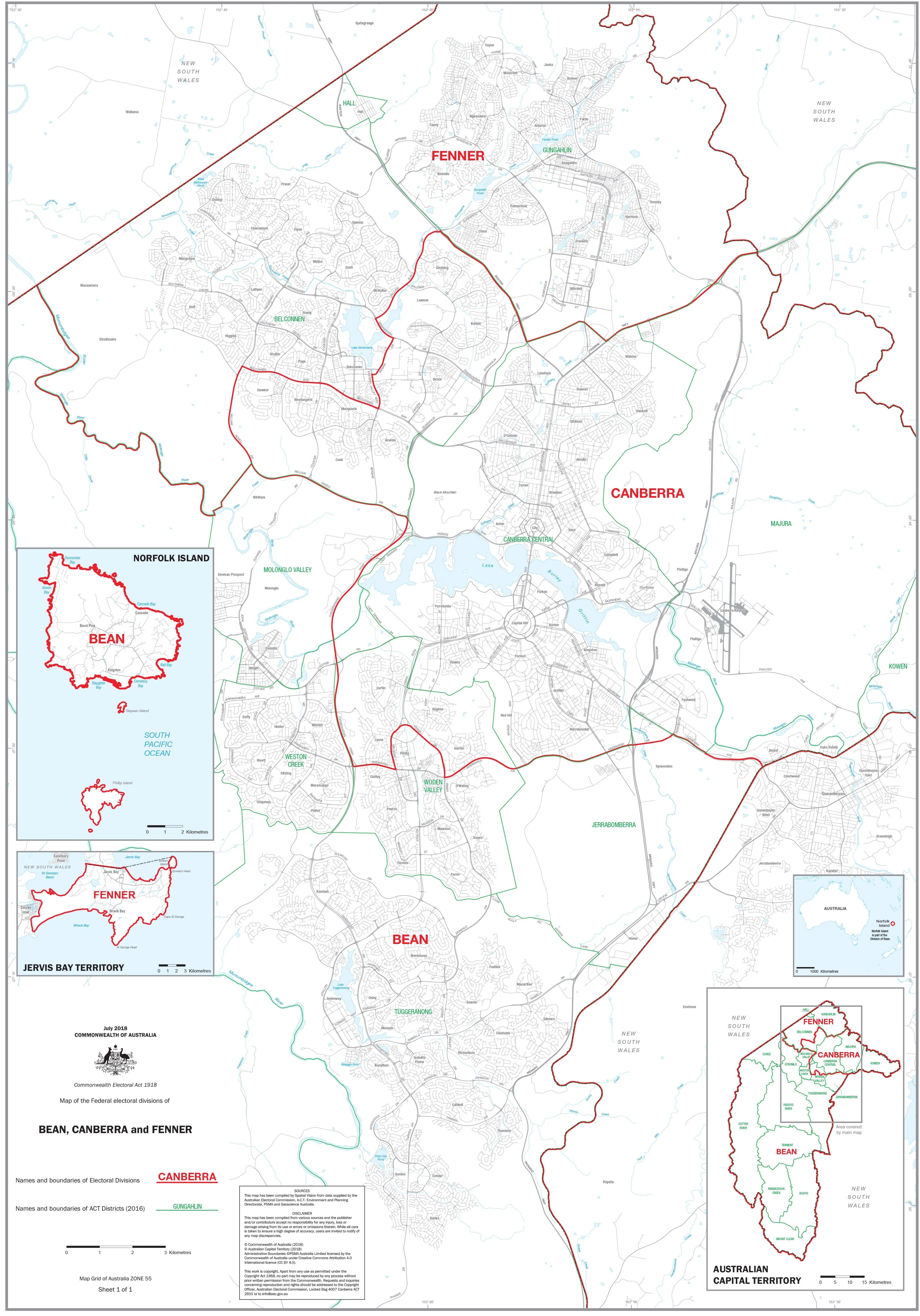
ACT Federal Electoral Divisions & Local Government Areas — Administrative Map
1000 × 700 mm • Paper / Laminated / Laminated + Hang Rails / Canvas / Canvas + Hang Rails • Printed in Australia
A clear, wall-readable reference of the Australian Capital Territory’s three federal electoral divisions—BEAN, CANBERRA, and FENNER—plus all ACT Local Government Areas (LGAs). Ideal for offices, classrooms, community spaces, and election operations.
🧭 At a Glance (What’s on the Map)
-
Federal divisions shown: BEAN, CANBERRA, FENNER (names & boundaries)
-
Local Government Areas: complete LGA names & boundaries across the ACT
-
Orientation aids: legend, scale bar, neatline, major features for quick reference
-
Wall-readable design: crisp boundary hierarchy and uncluttered labels
🎯 Why This Map Works
-
Dual-layer clarity — view federal divisions and LGAs together for efficient planning and communication
-
Planning-ready — perfect for election prep, community outreach, service coverage, and reporting
-
Professional finish — clean cartography that holds up in meeting rooms and public display
-
Durable options — laminate for daily annotation, or canvas for a premium wall feature
🧰 Customisation (On Request)
-
Individual Division Maps: Order detailed stand-alone maps of BEAN, CANBERRA, or FENNER
-
Branding & overlays: add logos, office locations, or service regions
-
Alternate sizes: scale to suit boardrooms or compact walls
🎨 Finishes & Display Options
-
📄 Paper — Heavyweight 160 gsm (Matte)
Smooth, low-glare stock ideal for framing under glass. -
💧 Laminated — True Encapsulation
Printed on 120 gsm and sealed in 2 × 80-micron gloss laminate (edge-sealed).
Wipe-clean • Tear-resistant • Moisture-safe — use non-permanent whiteboard markers and map dots. -
🪵 Laminated + Timber Hang Rails — Ready to Hang
Natural lacquered timber rails (top & bottom) with a top hanging cord for a frame-free, polished display.
Please allow up to 10 working days for rail fitting. -
🖼️ Canvas — HP 395 gsm Professional Matte
Gallery-grade canvas printed with pigment-based, fade-resistant inks for long-life colour. -
🪵 Canvas + Timber Hang Rails
Same premium canvas, finished with natural timber rails + top hanging cord.
Please allow up to 10 working days for rail fitting.
Dry-erase markers are recommended only on laminated versions.
📐 Specifications
| Attribute | Details |
|---|---|
| Title | ACT Federal Electoral Divisions & Local Government Areas — Administrative Map |
| Coverage | Australian Capital Territory (ACT), Australia |
| Content | Federal divisions (BEAN, CANBERRA, FENNER) + LGA names & boundaries |
| Map Type | Administrative (Federal Electoral + Local Government) |
| Size | 1000 mm (H) × 700 mm (W) |
| Formats | Paper • Laminated • Laminated + Hang Rails • Canvas • Canvas + Hang Rails |
| Paper | 160 gsm matte |
| Laminate | 2 × 80-micron gloss, true encapsulation (edge-sealed) |
| Canvas | HP 395 gsm Professional Matte |
| Inks | Pigment-based, fade-resistant |
| Origin | Printed in Australia |
| Lead Time | Hang-railed finishes: up to 10 working days |
🧽 Mounting & Care
-
Laminated: Use non-permanent whiteboard markers; wipe with a dry microfibre cloth (lightly damp if needed).
-
Paper: Frame under glass; avoid direct sunlight.
-
Canvas: Dust gently; avoid liquids and prolonged direct sunlight.
-
Hanging tip: For rail versions, use a centred wall hook and allow the map to hang naturally.
🤝 Our Commitment
-
Local craftsmanship: Designed, printed, and finished in Australia.
-
Premium materials: FSC-style papers, archival HP pigment inks, and HP 395 gsm Professional Matte Canvas for long service life.
-
Colour-managed output: Consistent, wall-readable cartography across your series.
-
Sustainable mindset: Durable finishes that extend product life and reduce waste.
-
Hand-checked & securely packed: Every map is inspected and boxed to arrive clean and display-ready.
Put the ACT’s federal divisions and LGAs on one clear, authoritative map.
Choose your finish and add to cart — or ask for an individual division map tailored to your needs.
Description
ACT Federal Electoral Divisions & Local Government Areas — Administrative Map
1000 × 700 mm • Paper / Laminated / Laminated + Hang Rails / Canvas / Canvas + Hang Rails • Printed in Australia
A clear, wall-readable reference of the Australian Capital Territory’s three federal electoral divisions—BEAN, CANBERRA, and FENNER—plus all ACT Local Government Areas (LGAs). Ideal for offices, classrooms, community spaces, and election operations.
🧭 At a Glance (What’s on the Map)
-
Federal divisions shown: BEAN, CANBERRA, FENNER (names & boundaries)
-
Local Government Areas: complete LGA names & boundaries across the ACT
-
Orientation aids: legend, scale bar, neatline, major features for quick reference
-
Wall-readable design: crisp boundary hierarchy and uncluttered labels
🎯 Why This Map Works
-
Dual-layer clarity — view federal divisions and LGAs together for efficient planning and communication
-
Planning-ready — perfect for election prep, community outreach, service coverage, and reporting
-
Professional finish — clean cartography that holds up in meeting rooms and public display
-
Durable options — laminate for daily annotation, or canvas for a premium wall feature
🧰 Customisation (On Request)
-
Individual Division Maps: Order detailed stand-alone maps of BEAN, CANBERRA, or FENNER
-
Branding & overlays: add logos, office locations, or service regions
-
Alternate sizes: scale to suit boardrooms or compact walls
🎨 Finishes & Display Options
-
📄 Paper — Heavyweight 160 gsm (Matte)
Smooth, low-glare stock ideal for framing under glass. -
💧 Laminated — True Encapsulation
Printed on 120 gsm and sealed in 2 × 80-micron gloss laminate (edge-sealed).
Wipe-clean • Tear-resistant • Moisture-safe — use non-permanent whiteboard markers and map dots. -
🪵 Laminated + Timber Hang Rails — Ready to Hang
Natural lacquered timber rails (top & bottom) with a top hanging cord for a frame-free, polished display.
Please allow up to 10 working days for rail fitting. -
🖼️ Canvas — HP 395 gsm Professional Matte
Gallery-grade canvas printed with pigment-based, fade-resistant inks for long-life colour. -
🪵 Canvas + Timber Hang Rails
Same premium canvas, finished with natural timber rails + top hanging cord.
Please allow up to 10 working days for rail fitting.
Dry-erase markers are recommended only on laminated versions.
📐 Specifications
| Attribute | Details |
|---|---|
| Title | ACT Federal Electoral Divisions & Local Government Areas — Administrative Map |
| Coverage | Australian Capital Territory (ACT), Australia |
| Content | Federal divisions (BEAN, CANBERRA, FENNER) + LGA names & boundaries |
| Map Type | Administrative (Federal Electoral + Local Government) |
| Size | 1000 mm (H) × 700 mm (W) |
| Formats | Paper • Laminated • Laminated + Hang Rails • Canvas • Canvas + Hang Rails |
| Paper | 160 gsm matte |
| Laminate | 2 × 80-micron gloss, true encapsulation (edge-sealed) |
| Canvas | HP 395 gsm Professional Matte |
| Inks | Pigment-based, fade-resistant |
| Origin | Printed in Australia |
| Lead Time | Hang-railed finishes: up to 10 working days |
🧽 Mounting & Care
-
Laminated: Use non-permanent whiteboard markers; wipe with a dry microfibre cloth (lightly damp if needed).
-
Paper: Frame under glass; avoid direct sunlight.
-
Canvas: Dust gently; avoid liquids and prolonged direct sunlight.
-
Hanging tip: For rail versions, use a centred wall hook and allow the map to hang naturally.
🤝 Our Commitment
-
Local craftsmanship: Designed, printed, and finished in Australia.
-
Premium materials: FSC-style papers, archival HP pigment inks, and HP 395 gsm Professional Matte Canvas for long service life.
-
Colour-managed output: Consistent, wall-readable cartography across your series.
-
Sustainable mindset: Durable finishes that extend product life and reduce waste.
-
Hand-checked & securely packed: Every map is inspected and boxed to arrive clean and display-ready.
Put the ACT’s federal divisions and LGAs on one clear, authoritative map.
Choose your finish and add to cart — or ask for an individual division map tailored to your needs.